PROJECT OVERVIEW -The Park's history is the history of its users.
The Mountain Lake Project is an interactive interpretive system for the newly renovated trails circumscribing Mountain Lake. The main objective is to create a system, which serves to relay some history of Mountain Lake Park while simultaneously recording the history that is constantly being created at the site. Further, this project aims to provide a connection point for those users of the Park who desire a connection to the Park or its inhabitants.
In assessing the needs of the Park, it became evident that the site is already highly regimented and overly coded. There are various forms of signage, some rather arbitrarily placed, which clutter such a small environment. The trails are primarily dictated by the Park Service, meaning that there is little choice involved in the use of the trails. The adjacent Highway infringes on the Park with near constant noise. Therefore, this project endeavors to remain visually discrete and optionally exploitable. Should a visitor to the Park choose, they may interact with the Trail project, but the space should not be geared to always need that form of interaction. The project attempts to relay history as individual memories and notations, based on the assertion that the Park's history is the history of its users. Surely, these are the people who inhabit and alter its landscape daily. They know what secrets it holds for them. In this sense, the park is a beautiful container for memory and emotion. Acting from this assertion, this Trails Forever Project will be an online container for the users memories and emotions. This will involve an online interactive website, movable icons, and optional text. SIGNIFICANCE OF PROJECT
This project has several aims. The primary aim is to create an interpretive system for the Mountain Lake Park trail system. This is pertinent the recent renovation, due to the lack of any cohesive interpretive system. This system is to link the community and reveal: lines of communication, links to personal histories and modern mythologies.
The first question to consider is what the uses of the park are. The initial effort to understand how Mountain Lake Park is used was made in contacting The Presidio Trust and the Golden Gate National Recreation Area and discussing the project with them. The next step was to visit the Park and directly observe and experience it. This provided a limited personal understanding of the functioning of the park. Surveys were created from the information gathered during the individual excursion and the meetings with the managing authorities. These were then used to interview people utilizing the Park. Meeting with the managing authorities established both their hopes for the project, as well as the restraints placed on the project. These meetings further profited the project in four key ways: an understanding of the official history of the Park was gained, the renovation was explained, future plans for the Park elucidated, and a connection to the managing authority was established. While the authorities do dictate the course that the Park will take, they rely on visitors to maintain much of the space. There is a program in place whereby an individual or group may, after minimal training, provide upkeep and maintenance on their own.
In accessing the park individually, it became apparent that the space is rather limited and somewhat inflexible. As described in the project overview, there are many forces that act on the park, overcoding the space. This provides a challenge to the project. Despite this fact, there are many activities that take place in the park. Dog walkers use it, joggers run the trails, children and families recreate by feeding the waterfowl, utilizing the playground, and strolling, Internet research has also shown that various groups meet at the park as well. For example, a Boston Terrier group holds their meetings at the park on occasion. There's even a "Friends of Mountain Lake Park" group.
Survey Questions
1. WHERE DO YOU LIVE?
2. HOW OFTEN DO YOU USE THE PARK?
3. WHAT IS YOUR MOST COMMON USE FOR THE PARK?
4. WHAT DO YOU PERCEIVE TO BE THE MOST COMMON USE OF THE PARK?
5. WHERE DO YOU ENTER THE PARK?
6. WHAT IS YOUR FAVORITE ASPECT OF THE PARK?
7. WHERE IS YOUR FAVORITE SPOT IN THE PARK?
8. WHAT DO YOU DO IN THAT SPOT?
9. WHY IS IT YOUR FAVORITE?
10. WHAT DO YOU IMAGINE TO BE THE HISTORY OF THAT SPOT?
11. WHAT SOUND COMES TO MIND WHEN YOU THINK OF THAT SPOT?
12. WHAT SMELL COMES TO MIND WHEN YOU THINK OF THAT SPOT?
13. WHICH PART OF THE PARK DO YOU LEAST FREQUENTLY USE? WHY?
14. WHAT DO YOU WANT TO KNOW ABOUT THE PARK?
15. WHAT DO YOU ALREADY KNOW ABOUT THE PARK?
16. DO YOU BELONG TO A GROUP OR ORGANIZATION THAT UTILIZES THE PARK?
The responses served to better understand the needs of the community and acted as the basis for the project. The direct observation helped to augment this questionnaire and fill-in any gaps in its data.
The conclusions that were reached through the data gathered, were that the Park is highly personal while equally public, and that it serves as a place for both relaxation and activity. For this reason, participation with the system must be optional and indiscrete. Furthermore, it was determined that because the Park inhabits the private sphere, any interpretation system must not be didactic. The work of interpretation should, for the most part, take place on the part of the user, rather than on the part of the designer. Consequently, internet-based or wireless technologies are the most practical and ideal media through which to interpret the Park.
The community significance of the project is threefold. The project allows for a wide range of activities on the part of the local community to be considered and discussed. It is gives a voice to said community as well as providing a subjective record of that community. DETAILED PROJECT DESCRIPTION
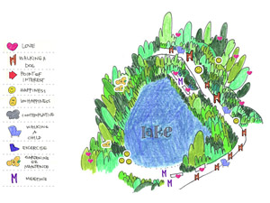
The home page will be a map of the park upon which the visitor may contribute by adding an icon. There are 10 icons indicating both use and emotion (more can be added): a heart symbolizes love, a dog = walking a dog, an arrow = a point of interest, a smiley face = happiness, a frown = unhappiness, a stroller = the walking a child, a shoe = running or exercising, a cloud = contemplation, a flower = gardening or maintenance, an "M" = the meeting of a group.  [click sprout to link to visuals]. These can be augmented by individually designed icons, an option that will be facilitated via a downloadable icon-design program. These new icons will be loaded on to the site and made available to all users. [click sprout to link to visuals]. These can be augmented by individually designed icons, an option that will be facilitated via a downloadable icon-design program. These new icons will be loaded on to the site and made available to all users.
These icons are to be placed on the map in the areas where they occur, and will themselves be selectable should any specific information be attached to them, (ie "today we sat by the lakeshore and talked"). Depending on frequency and volume of use, the map will be cycled every week, with each week's map saved and logged. There will be a link to previous weeks maps.
FUTURE DEVELOPMENT
-A forum or community note board where concerns or questions about the Park can be voiced. While this page is intended primarily to be used by visitors to the Park, it will contain links to the official Presidio and Golden Gate National Recreation Area websites, as well as provide contact information for the managing authority.
- A diary or memory recorder. The objective of this page is to create an online databank of communal stories and histories with the possibility for response to entries.
- A page that houses memories in the form of images. Specifically, the page will provide the option of uploading a digital file on to the webpage.
- Map for environmental monitoring/action breaking the park up in to 4 visual maps, or vectors, that will focus on a designated space along the trail. This page will mimic the interaction on the main homepage. There icons indicating plant and birds types. They may be placed in the appropriate vector and information when selected.
-Relative Links |